TRENDING

Monday, 5 October 2026
----------------------
24 Rabi' Al-Thani 1448 AH
Britain's national mapping agency, Ordnance Survey, is now on the front lines of climate change, using advanced tech to track eroding coastlines, flood risks, and wildfires. This shift reveals a nation grappling with the accelerating costs and human toll of a changing environment.
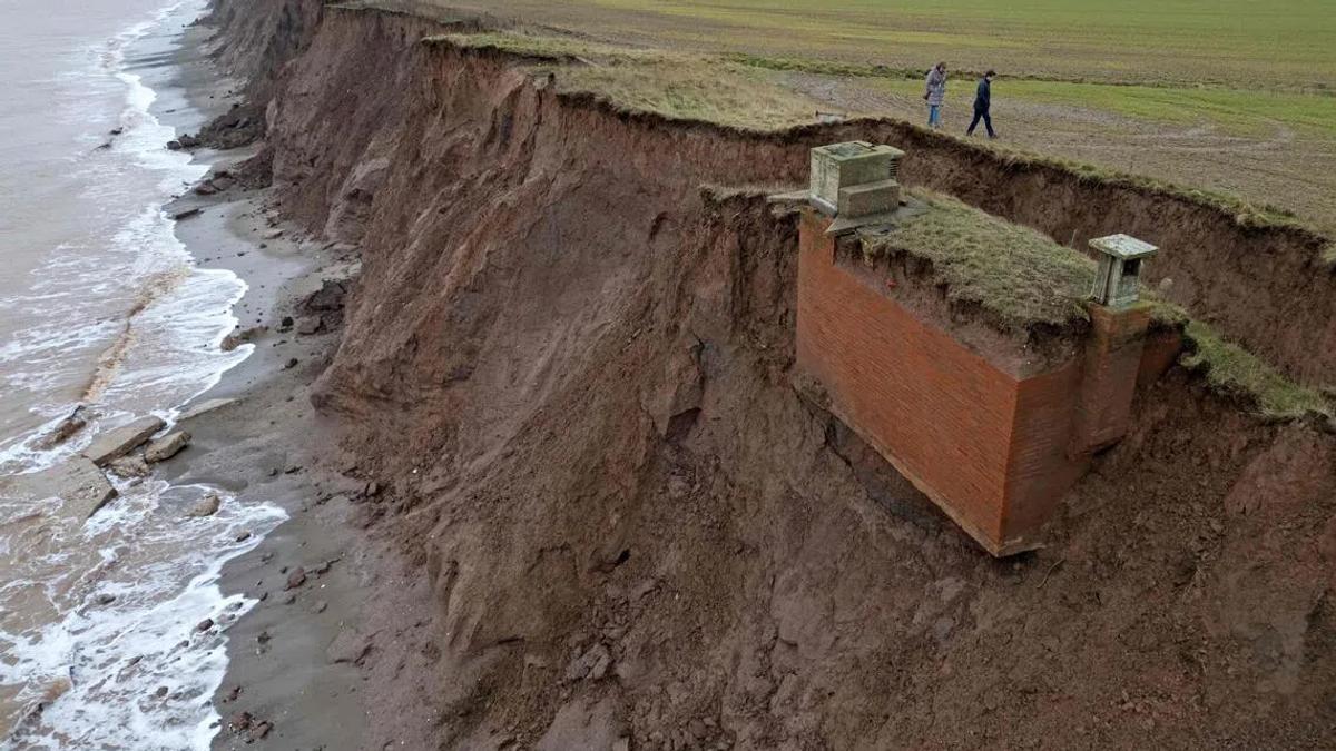
Britain's national mapping agency, Ordnance Survey (OS), is leveraging its centuries-old expertise and advanced technology to precisely track the accelerating impacts of climate change across the UK. With a history stretching back 230 years to defend against Napoleonic France, OS now finds itself on a new front line, documenting everything from coastal erosion causing a decommissioned Cold War nuclear observation post to slide into the sea, to widespread flooding risks threatening vital infrastructure. This fundamental shift highlights how a tool once used for military defense is now critical for understanding and adapting to an environmental crisis.
The UK government, through its national mapping agency, is effectively re-tasking a strategic asset towards climate adaptation. This reflects a growing, albeit belated, recognition that climate change poses a direct and immediate threat to national security, economic stability, and public welfare. The power in this scenario lies fundamentally in information: OS's highly detailed, frequently updated data, collected via drones and integrated into a vast National Geographic Database, provides authorities with an unparalleled advantage. This granular understanding of vulnerabilities—down to 1cm accuracy on buildings and infrastructure—becomes a strategic asset, influencing future zoning regulations, infrastructure investment decisions, and the coordination of emergency protocols.
The incentive for the state is multifaceted, touching upon political survival and economic stability. Unchecked climate impacts lead directly to public discontent, massive economic losses from damaged infrastructure and property, and an overwhelming strain on public services. By proactively mapping and planning, even if the primary mode is reactive crisis management, the government aims to demonstrate essential governance and mitigate the most severe consequences. This also signals a quiet technological arms race against environmental degradation, where advanced mapping tools are the new instruments of national defense, providing the intelligence needed to protect a changing homeland.
While the maps chart the physical changes, the human cost is borne by specific populations and communities. People living in coastal communities, flood plains, or wildfire-prone rural areas face the constant threat of losing homes, livelihoods, and the very fabric of their community ties. The dramatic example of the nuclear observation post sliding away serves as a stark metaphor for the vulnerability of human-built structures and the lives invested in them.
The economic burden extends beyond immediate property damage. Homeowners in affected zones face rising insurance premiums, decreased property values, and the profound emotional toll of repeated displacement or loss. Ultimately, taxpayers across the nation bear the significant costs of infrastructure repairs, emergency services, and the long-term, often colossal, adaptation projects required. The OS data reveals that 12% of the UK’s strategic road network and 20% of its rail network are in the highest flood risk zones. This translates to disrupted commutes, fractured supply chains, and hindered access to essential services for millions, underscoring how climate impacts ripple through daily life. The communities most exposed to these changes often have the least direct influence on the large-scale planning and policy decisions that could mitigate their risks or provide adequate compensation, making them the silent recipients of a changing map.
While the Ordnance Survey's meticulous work is commendable in its precision and utility for emergency response, the broader narrative often downplays several critical aspects. Firstly, there is a subtle omission of the systemic political and economic failures that have led to such widespread vulnerability. The focus on *adapting* and *responding* to climate change, while necessary, often overshadows the more fundamental need for aggressive *mitigation* policies to drastically reduce greenhouse gas emissions in the first place. The maps show the symptoms, but the underlying disease of inadequate climate action is less discussed.
Secondly, the article highlights the utility of mapping for emergency services but largely omits the staggering financial investment required to actually *implement* large-scale adaptation measures. Relocating entire communities, constructing extensive sea defenses, or fundamentally upgrading vast swathes of national infrastructure will demand colossal sums. The question of who will ultimately bear this financial burden—taxpayers, private industry, or a combination—remains largely unaddressed by official statements.
Finally, there's a downplaying of political accountability. While surveyors on the ground observe the direct impacts of drought and other extreme weather, there is little discussion of the political choices (or lack thereof) over decades that have permitted development in high-risk areas or failed to adequately fund climate resilience. The narrative, while emphasizing preparedness, can inadvertently create an illusion that technology and reactive measures alone can solve a problem rooted in deeper environmental and political dynamics. The data shows *what is happening*, but not necessarily *why it was allowed to happen* or *how to fundamentally change course*.
Readers should closely watch several key indicators. Firstly, observe how much the UK government allocates to actual physical adaptation projects beyond just mapping and emergency response. Will the detailed maps translate into concrete, large-scale infrastructure investments and potentially difficult land-use policy changes, or will they primarily serve to refine crisis management? Secondly, monitor how the insurance industry responds to this increasingly granular risk data. Will premiums skyrocket, rendering certain areas financially unviable for residents, and what will be the social and economic fallout of such market shifts? Thirdly, assess the political appetite for making difficult decisions, such as managed retreat from highly vulnerable coastlines or imposing stringent restrictions on development in floodplains. How will public pressure, fueled by increasingly visible climate impacts, influence these choices in the coming years? Finally, while this analysis focuses on the UK, the underlying issue is global. Watch for how this detailed national mapping approach influences or is influenced by international efforts to standardize climate vulnerability assessments and adaptation strategies, as nations worldwide grapple with similar challenges.
Source referenced: STRAITSTIMES
This brief was synthesized by our Editorial Engine and reviewed by The Ground Narrative team.


